| Yosemite Valley | Tuolumne and Tioga Road | Hetch Hetchy | Wawona and Glacier Point |
Yosemite Wilderness Overview
The classic beauty and fascinating ecosystems of the Sierra Nevada mountain range are well represented in the wilderness of Yosemite National Park. Almost 95% of the Park is designated Wilderness. A place retaining its primeval character and influence, this wilderness area provides opportunities for solitude and unconfined types of experience. The lands within the wilderness range in elevation and life zones from 2,900' to 13,114' at the summit of Mt. Lyell. With over 800 miles of trail, visitors will find a spectrum of opportunities, of natural systems, and of levels of use. Use the following information, or that available at the permit issuance stations, to help you plan your Yosemite Wilderness Experience.
Four Regions of the Park - Click the image to read trail descriptions and distances. |
|
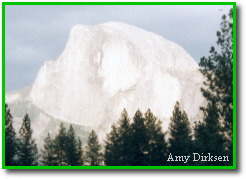
Beautiful and majestic, Yosemite Valley boasts some of the most popular trailheads in the park. These strenuous trails lead the hiker up the seemingly sheer granite walls which form the Valley. To reach the top of such spectacles as Half Dome, Yosemite Falls, Glacier Point, and El Capitan, the hiker will encounter steep terrain, switchbacks, and rapidly changing weather conditions. Spectacular views from the rim of the valley reward the hiker and quickly erase memories of any hardships suffered enroute.
|
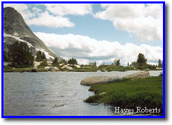 Tuolumne
and Tioga Road Tuolumne
and Tioga RoadTuolumne Meadows is located at over 8600 feet in
elevation. From Tuolumne, numerous trails lead hikers to lakes, meadows and beautiful
river canyons. More strenuous overnight backpacking trips allow the adventurer access to
the northern-most reaches of the Park, the area between Tuolumne Meadows and Yosemite
Valley, or along extended wilderness routes such as the John Muir Trail or the Pacific
Crest Trail. Because of its elevation, temperatures in Tuolumne average 15 to 20 degrees cooler than Yosemite Valley. Snow is not uncommon as late as June or as early as September. Peaks, such as Mt. Dana and Mt. Lyell retain snow throughout the summer and provide breathtaking views from their bases and summits. Once the Tioga Road closes for the season (generally in early November), this area is accessible to well-experienced winter enthusiasts via snow shoes or skis only. Tioga Road (State Route 120 East) : This
scenic 45 mile drive covers almost 4000 feet of elevation change. It begins at Crane Flat,
travels through Tuolumne Meadows, and then over Tioga Pass. The road is open to vehicles
from late May or June (weather permitting) until the first major snow storm after November
1. During this 1 1/2 hour drive, visitors pass through meadows and forests, lakes and
granite domes. Day hikes from the Tioga Road are abundant. For backpackers, there are also numerous trailheads. Some trails provide one way trips into Yosemite Valley. Others, less traveled but no less scenic, head into the northern part of the park. These trails travel through forested areas, deep canyons, past lakes, and finally above tree-line. In winter and early spring, the snow covered Tioga Road serves as an ungroomed cross-country ski route for the adventurous and seasoned winter camper.
|
|
The Hetch Hetchy Reservoir, located in the northwest part of the park,
serves as the portal to many beautiful, less-traveled areas in Yosemite. The Hetch Hetchy
Road normally stays open year-round and the reservoir itself lies at a relatively low 3900
feet making this a good area for spring and fall wilderness travel. High temperatures prevail along the trail during the summer months, but this is a small price to pay for the breathtaking areas that can be reached from here. Several lakes and popular valleys are all within 15 miles of the reservoir. Hikers may elect to begin longer trips here as well, either toward Tuolumne Meadows or the northern-most reaches of the park.
|
|
Historic Wawona at 4000 feet elevation is located just
inside the park's southern boundary on Highway 41. Because of its low elevation, trails
from Wawona can be accessible during the spring and fall as well as the summer. The lush
open meadows, forests and lakes which abound in Yosemite’s less-frequented southern
wilderness can be reached from trailheads in Wawona. The abundance of water in the spring
makes this an attractive area for wilderness users. Once under snow in winter, the Mariposa Grove of Giant Sequoias is designated as wilderness. Nordic skiers and snow-shoers can obtain a wilderness permit to ski through and camp in the upper reaches of the Grove. At an elevation of 7200 feet, Glacier Point offers a
spectacular view of Half Dome, Vernal and Nevada Falls, Yosemite Valley and the Clark
Range. It serves as the trailhead for many popular day hikes and provides access to the
less traveled wilderness areas in the southern portion of Yosemite. Driving time from Yosemite Valley to Glacier Point is about one hour. The Glacier Point Road is generally open from late May to late October. In winter, it serves as a groomed cross-country ski track starting from the Badger Pass ski area. Badger Pass, located 6 miles from the Chinquapin turn off on Highway 41, also serves as the trailhead for numerous marked cross-country ski trails. Wilderness permits for overnight wilderness travel from Badger Pass should be acquired from the Badger Pass A-Frame.
|
http://www.nps.gov
File created 9/99 Hayes Roberts
Updated
Yosemite National Park Division
of Interpretation
 Yosemite Valley
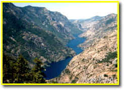 Hetch Hetchy
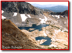 Wawona and Glacier Point