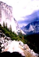
Yosemite Valley Trail Descriptions and Distances (All distances approximate and one way)
| Trail | Destinations | Miles | Km | Brief Description |
| Happy Isles Trailhead
|
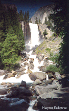
Vernal Falls Bridge | 0.8 | 1.3 | This very popular trail is heavily used by both day and overnight hikers. Day hikers can travel to Vernal and Nevada Falls along the cascading Merced River. Overnight hikers can continue on to Little Yosemite Valley and Half Dome. Camping in Little Yosemite Valley is limited to the designated backpacker campground. Camping is not allowed at the top of Vernal or Nevada Falls, or on the top of Half Dome. One can also hike beyond the Little Yosemite Valley/Half Dome area on the John Muir Trail or toward Merced Lake. The northern end of the John Muir Trail to Mt. Whitney begins here. Backpackers must travel at least two miles beyond Little Yosemite Valley before camping, if not staying in Little Yosemite Valley. |
| Top of Vernal Fall | 1.5 | 2.4 | ||
| Top of Nevada Fall via Mist Trail | 2.5 | 4.0 | ||
| Top of Nevada Fall via John Muir Trail | 3.4 | 5.4 | ||
| Little Yosemite Valley | 4.7 | 7.5 | ||
| Glacier Point | 8.2 | 13.1 | ||
| Half Dome | 8.2 | 13.1 | ||
| Cloud's Rest | 10.5 | 16.8 | ||
| Merced Lake | 13.1 | 21.0 | ||
| Tenaya Lake via Sunrise Trail | 16.4 | 26.2 | ||
| Tenaya Lake via Cloud's Rest | 17.9 | 28.6 | ||
| Tuolumne via Sunrise | 21.2 | 33.9 | ||
| Tuolumne via Vogelsang | 27.3 | 43.7 | ||
| Mt. Whitney via John Muir Trail | 211.0 | 337.6 | ||
| Mirror
Lake - Snow Creek
|
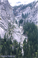
Top of Snow Creek Falls | 3.7 | 5.9 | This trail is the steepest climb out of Yosemite Valley, taking hikers up switchbacks toward Snow Creek, North Dome, and the north rim of the Valley. Day hikers can enjoy the very beginning of the hike to Mirror Lake and the Tenaya Canyon Loop Trail. Overnight hikers must travel 4 miles beyond the valley floor before camping. |
| North Dome | 9.0 | 14.4 | ||
| Top of Yosemite Falls | 14.0 | 22.4 | ||
| Top of El Capitan | 18.1 | 29.0 | ||
| North Rim Trail to Foresta Junction | 22.9 | 36.6 | ||
| May Lake | 11.2 | 17.9 | ||
| Tenaya Lake | 11.3 | 18.0 | ||
| Tuolumne Meadows | 20.0 | 32.0 | ||
| Yosemite Falls | Top of Yosemite Falls (No Camping) | 3.5 | 5.6 | Yosemite Falls is a very strenuous hike up switchbacks to the top of the falls, the north rim of the valley, and beyond. Day hikers may climb part or all of the way to the top of Yosemite Falls. This is the primary access point for overnight hikers wishing to travel along the north rim of the valley, along Yosemite Creek, or to the top of El Capitan. Overnight hikers must travel at least 4 miles before camping and camp at least � mile beyond the top of Yosemite Falls. |
| Yosemite Point (No Camping) | 4.5 | 7.2 | ||
| North Dome | 8.5 | 13.6 | ||
| Eagle Peak | 6.0 | 9.6 | ||
| El Capitan | 7.9 | 12.6 | ||
| Tioga Road via Porcupine Creek | 9.2 | 14.7 | ||
| Tioga Road via Yosemite Creek | 11.3 | 18.1 | ||
| White Wolf | 14.0 | 22.4 | ||
| Harden Lake | 17.0 | 27.2 | ||
| Ten Lakes | 17.6 | 28.2 | ||
| Four Mile Trail
|
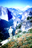
Glacier Point (No Camping) | 4.8 | 7.7 | The Four Mile Trail, primarily
used by day hikers, travels up switchbacks from the valley floor to Glacier Point
providing many stunning vistas of the valley en route. Overnight camping is not allowed
along the Four Mile Trail. Hikers may choose to shuttle cars or pay to take a bus to
Glacier Point and hike down this trail.
|
| Wawona Tunnel—Pohono
Trail
|
Old Inspiration Point | 1.2 | 1.9 | Hikers can access the western end of the Pohono trail from the Wawona Tunnel. Day hikers can make a short, but steep, trip to Old Inspiration Point. Overnight hikers can travel on to the best campsite along this trail at the Bridalveil Creek bridge. |
| Dewey Point | 7.0 | 11.2 | ||
| Bridalveil Creek Junction | 9.0 | 14.4 | ||
| Taft Point Junction (No Camping) | 10.6 | 17.0 | ||
| Glacier Point (No Camping) | 13.0 | 20.8 | ||
| Big Oak
Flat From Foresta
|
Old Big Oak Flat Road | 4.0 | 6.4 | This trail passes through the area burned in the 1990 fires and crosses two unbridged creeks which can be difficult in the spring. It is often used to access the top of El Capitan. |
| Top of El Capitan | 10.6 | 17.0 | ||
| Top of Yosemite Falls (No Camping) | 13.2 | 21.1 | ||
| North Dome | 17.9 | 28.6 |
Tuolumne Trails , Tioga Road Trails
Wawona and Glacier Point Trails
http://www.nps.gov
File created 9/99 Hayes Roberts
Updated
Yosemite National Park Division
of Interpretation