| Trail |
Destinations |
Miles |
Km |
Brief
Description |
| Sunrise/Cloud's
Rest 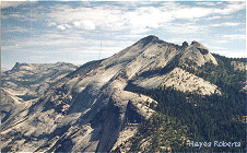
|
Sunrise Lakes |
3.3 |
5.3 |
This trail
is the starting point for day and overnight hikers climbing up to Sunrise Lakes and
Cloud's Rest. Overnight hikers can choose to continue around the High Sierra Camp loop
trail to Merced Lake, toward Half Dome and the Little Yosemite Valley, or toward Cathedral
Lakes and Tuolumne Meadows. You must travel at least one mile beyond Tenaya Lake before
camping. |
| Sunrise High Sierra Camp |
5.8 |
9.3 |
| Cloud's Rest |
7.4 |
11.8 |
| Yosemite Valley via Sunrise
Trail |
16.3 |
26.1 |
| Yosemite Valley via Cloud's Rest |
17.9 |
28.6 |
| Yosemite Valley via Olmsted
Point/Mirror Lake |
10.8 |
17.3 |
| Tuolumne Meadows via Cathedral
Lakes |
14.0 |
22.4 |
| Cathedral
Lakes- John Muir Trail |
Cathedral
Lakes |
3.4 |
5.4 |
This trail leads both day and overnight hikers into the
heart of the Cathedral Range. This very popular trail is also part of the John Muir Trail.
Overnight hikers must reach the Cathedral Lakes basin before camping. Wood fires are
not allowed in this area. |
| Sunrise High Sierra Camp |
7.7 |
12.4 |
| Yosemite Valley via Sunrise
Creek |
21.2 |
33.9 |
| Yosemite Valley via Echo Creek |
26.1 |
41.8 |
| Merced Lake |
16.4 |
26.2 |
| Tenaya
Lake via Sunrise Lakes |
14.0 |
22.4 |
| Rafferty Creek/ Vogelsang 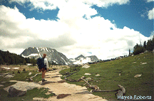
|
Vogelsang High Sierra Camp |
6.9 |
11.0 |
This trail begins by following the Lyell Fork of the Tuolumne River through
sub-alpine meadows and then climbs along Rafferty Creek toward Tuolumne Pass, Vogelsang
and destinations beyond. |
| Merced Lake via Fletcher Creek |
14.9 |
23.8 |
| Merced Lake via Lewis Creek |
15.7 |
25.1 |
| Isberg Pass |
25.4 |
40.6 |
| Yosemite Creek via Fletcher
Creek |
27.7 |
44.3 |
| Tuolumne Pass |
6.3 |
10.0 |
| Murphy Creek |
Polly Dome Lakes |
2.5 |
4.0 |
Hikers on this trail will travel across open granite slabs and through lodgepole
pine forests along Murphy Creek. |
| Glen Aulin |
6.8 |
10.9 |
| May Lake |
7.0 |
11.2 |
| Elizabeth/Nelson Lakes |
Elizabeth Lake (No Camping) |
2.5 |
4.0 |
Day hikers will find a pleasant hike climbing through lodgepole pine forest to
Elizabeth Lake at the base of Unicorn Peak. Overnight hikers traveling beyond Elizabeth
Lake must be prepared for cross country travel and must travel at least 1.5 miles beyond
Elizabeth Lake before overnight camping. |
| Nelson Lake (Cross Country) |
5.5 |
8.8 |
| Lyell
Canyon- John Muir Trail 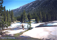
|
Ireland
Creek Junction |
5.2 |
8.3 |
This trail meanders through Lyell Canyon mostly alongside
the Lyell Fork of the Tuolumne River toward Donahue Pass. This is also the John Muir Trail
and the starting point for many long distance hikers heading towards Devil's Postpile and
Whitney Portal. Approximately 5 miles into the canyon, it is joined by the Ireland Creek
trail which takes hikers toward Ireland Lake, Evelyn lake and Vogelsang. |
| Donahue
Pass |
12.1 |
19.4 |
| Devil's
Postpile |
32.7 |
52.3 |
| Whitney
Portal |
190 |
304 |
| Lyell
Canyon- Ireland Lake |
Ireland
Lake |
11.4 |
18.2 |
| Vogelsang
High Sierra Camp |
12.3 |
19.7 |
| Yosemite
Valley via Fletcher Creek |
32.3 |
51.7 |
| Mono/Parker
Pass 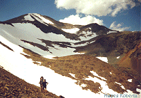
|
|
|
|
Day hikers will find
this high country trail a delight as they climb to over 10,000 feet along the Parker Pass
Creek drainage toward Mono and Parker passes and Spillway Lake. The Dana and Parker Pass
watershed, including Parker Pass Lake and the Kuna Crest lakes, is closed to overnight
camping. Hikers must exit the park before camping. |
Glen Aulin |
Twin Bridges (No Camping) |
4.0 |
6.4 |
This popular trail leads hikers along the Tuolumne River
through lodgepole pine forest, meadows and granite domes toward Glen Aulin. Beyond Twin
Bridges, the trail begins a descent along a series of waterfalls into the Grand Canyon of
the Tuolumne River. Overnight hikers must travel beyond Twin Bridges before camping or
must stay in the established sites in the backpacker campground if camping at Glen Aulin.
This trail is also the gateway for overnight hikers who plan to travel beyond Glen Aulin
deeper into the Grand Canyon of the Tuolumne toward Muir Gorge and Pate Valley or for
those traveling north of Glen Aulin toward Cold Canyon and the high country canyons of the
northeast portion of the park. |
| Glen Aulin |
5.3 |
8.2 |
| Waterwheel Falls |
8.2 |
13.1 |
| Pate Valley |
19.2 |
30.7 |
| White Wolf |
28.7 |
45.9 |
| May Lake |
12.5 |
20.0 |
| Yosemite Valley via May Lake |
22.9 |
36.6 |
| Virginia Canyon |
12.7 |
20.3 |
| Benson Lake |
29.5 |
47.2 |
| Gaylor
Lakes 
|
|
|
|
This area
is open to day hiking only. Hikers will climb from Tioga Pass to above the tree line on
the ridge to the north and then drop into the Gaylor Lakes basin. |
| Young Lakes
via Dog Lake 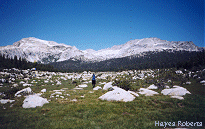
|
Dog Lake (No Camping) |
1.5 |
2.4 |
Day hikers on this trail will enjoy short trips to the top
of Lembert Dome and to Dog Lake. Overnight hikers will travel through meadows and forests
with panoramic views of the Cathedral Range as they climb higher toward Young Lakes near
the crest of the Sierra Nevada. |
| Young Lakes (No Fires) |
6.0 |
8.4 |
| |
|
|
| Young
Lakes via Glen Aulin |
|
|
|
Hikers
along this trail will travel through Tuolumne Meadows to Soda Springs, follow the Glen
Aulin trail for a short distance and then begin ascending through the lodgepole pine
forest toward Young Lakes where they will be surrounded by Ragged Peak, White Mountain and
Mt. Conness. |
| Budd Lake Trailhead 
|
Budd Lake (Cross Country - No
Camping) |
3.0 |
4.8 |
|