Wawona and Glacier Point Trail Distances and Descriptions (All distances approximate and one way)
| Trail | Destinations | Miles | Km | Brief Description |
| Chilnualna Falls
|
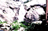
Chilnualna Falls | 5.0 | 8.0 | This trailhead serves both day hikers traveling to the top of Chilnualna Falls as well as overnight backpackers who travel further into the distinctive forests and lakes of the southwestern part of the park to places such as Grouse, Crescent, Royal Arch, Buena Vista, and Chilnualna Lakes. Backpackers can also travel toward Glacier Point to destinations such as Deer Camp and Bridalveil Creek. |
| Deer Camp | 11.2 | 17.9 | ||
| Bridalveil Campground | 14.0 | 22.4 | ||
| Johnson Lake (Royal Arch Junction) | 12.7 | 20.3 | ||
| Moraine Meadow | 19.7 | 31.5 | ||
| Merced Pass | 21.3 | 34.1 | ||
| Chain Lakes | 20.6 | 33.0 | ||
| Chiquito Pass | 18.9 | 30.2 | ||
| Fernandez Pass | 22.8 | 36.5 | ||
| Alder Creek Loop | 6.3 | 10.1 | ||
| Mariposa Grove
|
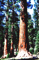
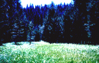
This trail meanders through the largest grove of majestic giant sequoia trees in the park. This is a very popular day hike in the summer. Visitors have the option of paying to take a guided tram tour to the top of the grove and then hiking or riding down. Overnight camping in this area is only allowed in the winter months; when access is limited to all but those who can ski or snowshoe. | |||
| Chiquito
Pass
|
Visitors using this trailhead, which actually begins just south of the park boundary in the Sierra National Forest, can access the remote southern area of the park including Chain Lakes, the Buena Vista Crest, and the Clark Range. | |||
| Alder Creek | This infrequently used trail climbs gradually through mixed conifer forest onto ridge tops above the South Fork of the Merced River. | |||
| Deer Camp Road | This old fire road turned trail takes hikers to Deer Camp, an old California Conservation Corp camp, and to many other wilderness destinations in southern Yosemite. | |||
| Wawona Meadow Loop | This easy walk begins across the highway from the Wawona Hotel, crosses the golf course and then follows an unpaved fire road through the forest around Wawona Meadow. There is no camping in this area. | |||
| Westfall Meadow | This trail is a pleasant day hike leading to Westfall meadow. Overnight hikers can continue on toward Deer Camp, Turner Ridge, and Chilnualna Falls. | |||
| Bridalveil Campground | Ostrander Lake | 6.1 | 9.8 | This trail begins alongside Bridalveil Creek and heads south where hikers can venture on to Ostrander Lake or toward Wawona. |
| Deer Camp | 4.1 | 6.6 | ||
| McGurk Meadow | Both day and overnight hikers can reach the south rim of Yosemite Valley from this trailhead. Overnight hikers can camp near Bridalveil Creek, or near several south rim vista points such as Dewey Point. | |||
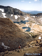
| Ostrander Lake / Lost Bear Meadow
|
Ostrander Lake | 5.2 | 8.3 | This trail is the most direct route to Ostrander Lake and follows the Bridalveil Creek drainage through beautiful forested terrain. |
| Mono Meadow
|
Edison Lake | 11.5 | 18.4 | The Mono Meadow trail is a very pleasant day hike. Day hikers can continue on to the Illilouette Creek for picnicking and fishing. Overnight hikers can gain access to the Buena Vista and Illilouette drainages and into the heart of the Clark Range. |
| Johnson Lake via Royal Arch Lake | 15.3 | 24.5 | ||
| Chilnualna Falls/ Wawona via Johnson Lake | 15.3 | 24.5 | ||
| Chilnualna Falls/ Wawona via Chilnualna Lakes | 33.4 | 54.4 | ||
| Nevada Fall Trail Junction | 4.9 | 7.8 | ||
| Merced Peak/ Red Peak Junction | 12.1 | 19.4 | ||
| Ottoway Lakes | 16.0 | 25.6 | ||
| Buck Camp Vicinity | 20.7 | 33.1 | ||
| Top of Nevada Fall | 6.9 | 11.0 | ||
| Happy Isles | 10.3 | 16.5 | ||
| Pohono Trail From Glacier Point | Wawona Tunnel | 13.0 | 21.0 | The Pohono Trail takes hikers along the south rim of Yosemite Valley. Day hikers can take the Pohono Trail to the stunning vistas at Sentinel Dome and Taft Point. Overnight hikers will have to continue on to Bridalveil Creek before overnight camping. The Pohono Trail can be taken all the way to Highway 41 at the Wawona Tunnel. |
| Pohono Trail From Taft | Wawona Tunnel | 10.6 | 17.0 | The Pohono Trail can also be accessed via the trail to Taft Point, leading the day hiker to Taft point and Sentinel Dome, and the overnight hiker west to Bridalveil Creek and along the southern rim of Yosemite Valley. |
| Glacier Point to Illilouette
|
Illilouette Creek/ Mono Meadow Junction | 3.6 | 5.8 | This trail drops quickly from Glacier Point into the Illilouette Creek drainage. Overnight hikers can use this trail to gain access to the Buena Vista and Illilouette Creek drainage's and into the heart of the Clark Range. |
| Lower Ottoway Lake | 15.8 | 25.3 | ||
| Red Peak Pass | 18.7 | 29.9 | ||
| Happy Isles via Red Peak Pass | 47.6 | 76.2 | ||
| Buena Vista Lake | 12.7 | 20.3 | ||
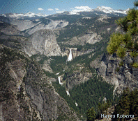
| Panorama Trail from Glacier
Point
|
Little Yosemite Valley | 5.2 | 8.2 | This trail is popular for both day and overnight hikers. Day hikers can hike to the top of Illilouette Falls, along the Panorama Cliffs and down the Vernal/Nevada Falls corridor to Yosemite Valley. Many people do this one way hike by shuttling cars or by paying to take a bus to Glacier Point. This trail is also very popular for overnight hikers wishing to travel to Little Yosemite Valley and Half Dome. Overnight hikers must travel to Little Yosemite Valley before camping. Camping in Little Yosemite Valley is limited to the designated backpacker campground. Overnight camping is not allowed at the bridge above Illilouette Fall, at the top of Nevada Fall or along the Panorama Cliffs. |
| Half Dome | 8.2 | 14.1 | ||
| Merced Lake | 14.3 | 22.9 | ||
| Cloud's Rest | 11.5 | 17.8 | ||
| Tenaya Lake via Sunrise Trail | 17.4 | 27.2 | ||
| Tuolumne via Sunrise | 22.2 | 34.9 | ||
| Tuolumne via Vogelsang | 28.3 | 44.7 |
http://www.nps.gov
File created 9/99 Hayes Roberts
Updated
Yosemite National Park Division
of Interpretation