

|
|
|
II. AlternativesIntroduction
The
Happy Isles Gauging Station Bridge is located along the Merced Wild
and Scenic River at Yosemite Valley’s easternmost end. This area is
a popular destination for park visitors who can enjoy short walks
around the tree-studded Happy Isles, as the river cascades
dramatically over gigantic boulders. Wayside exhibits help to
interpret the natural history of the area, including the diverse
communities of life (talus, river, fen, and forest) and the geologic
story of rockfalls in Yosemite. Just adjacent to the Happy Isles
Gauging Station Bridge is the Nature Center, located at the historic
Yosemite Fish Hatchery building. This family-oriented facility offers
exhibits
Happy Isles
Gauging Station Bridge has sustained extensive damage in recent years.
The bridge was damaged by felled trees during the massive rockfall and
related windblast in the Happy Isles area in July 1996. Happy Isles
Gauging Station Bridge was also severely damaged in a major flood in
January 1997 and then was deemed unsafe by representatives of the
Federal Highway Administration. Based on these findings, the National
Park Service closed the bridge for safety reasons in July 1997. Since
that time, the bridge has continued to deteriorate and is currently
showing signs of collapse, with a large sinkhole appearing on the
river-left abutment. Due to the threat to public health and safety,
the bridge needs to be removed before it collapses of its own accord.
The river-right abutment of the bridge needs to be retained in order
to protect the historic Happy Isles Gauging Station and streamflow
gauge, which is operated by the United States Geological Survey. The alternatives considered for the Happy Isles Gauging Station Bridge Removal Project include Alternative 1, the No Action Alternative and Alternative 2, Controlled Demolition (the preferred alternative). The action alternative eliminates a bridge safety hazard by partially removing the bridge, and protects the streamflow gauge by maintaining the river-right abutment. Organization of the ChapterThis chapter presents: · Overview of the alternatives · Alternatives considered but dismissed from further analysis · Action alternative mitigation measures · A table summarizing the environmental consequences of the alternatives This section presents two alternative approaches for the Happy Isles Gauging Station Bridge Removal Project. Each discussion includes a narrative description of the alternative. Alternative 2 is based on the purpose of and need for the project, and conforms with the goals of Yosemite National Park’s General Management Plan, the goals and management elements of the Merced Wild and Scenic River Comprehensive Management Plan, and associated goals and actions called for in the Yosemite Valley Plan. Under the No Action Alternative, the Happy Isles Gauging Station Bridge would remain in its existing condition without maintenance or repair. It is assumed, however, that the continued deterioration of the bridge would result in its uncontrolled collapse. Under Alternative 2, the Happy Isles Gauging Station Bridge would be partially removed using controlled demolition techniques. Under both alternatives, the Happy Isles Gauging Station Bridge would be lost – due to catastrophic collapse under the No Action Alternative and controlled removal under Alternative 2. Since both alternatives would result in the loss of the bridge, the primary difference between the alternatives is how the bridge would be removed and its effect on other resources in the immediate vicinity. Alternative 1: No ActionOverview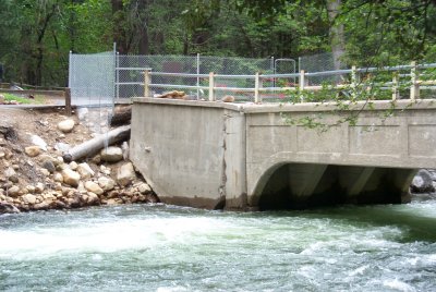 The
No Action Alternative maintains the status quo at the Happy Isles
Gauging Station Bridge, as described in Chapter III, Affected
Environment. It provides a baseline from which to compare the action
alternative, to evaluate the magnitude of proposed changes, and to
measure the environmental effects of those changes.
The
No Action Alternative maintains the status quo at the Happy Isles
Gauging Station Bridge, as described in Chapter III, Affected
Environment. It provides a baseline from which to compare the action
alternative, to evaluate the magnitude of proposed changes, and to
measure the environmental effects of those changes.
Under the No Action Alternative, Happy Isles Gauging Station Bridge would remain in its existing condition, without maintenance or repair. Since the bridge was damaged and closed to the public in 1997, no significant repairs have been made. The 1996 rockfall and windblast in the Happy Isles area damaged the bridge. In the following year, the January 1997 flood caused severe scour, with full-length undermining and loss of support to the river-left abutment of the bridge. Under the No Action Alternative, the Happy Isles Gauging Station Bridge would continue to pose a threat to public health and safety. Although the bridge is fenced off and access to it is prohibited, people occasionally climb the fence to cross the river or look at the bridge. In addition, this area is a popular location for swimming and wading. People recreating in the river near the bridge could be exposed to hazards due to falling bridge debris or bridge collapse, potentially resulting in human fatality. Under the No Action Alternative, no management action would be taken to repair or remove the historic bridge. This condition of benign neglect (see Glossary) would be expected to eventually result in the uncontrolled and sudden failure of the Happy Isles Gauging Station Bridge. Bridge collapse would likely occur during a period of high flow and it is assumed that this collapse would occur within the next ten years. Collapse of the bridge could result in extensive erosion, as well as uncontrolled release of bridge debris into the Merced River. Large chunks of concrete, rebar, and other bridge materials could dam the river, divert the river from its channel, and substantially erode the otherwise stable riverbanks in this area. Diverted river flows could also result in loss of vegetation along the riverbanks. Bridge debris could be deposited along the river channel and banks downstream to Happy Isles Vehicle Bridge and beyond. Sudden erosion could threaten the water supply lines located approximately 25 feet from the top of the bank. Such an uncontrolled collapse could also result in damage to the historic Happy Isles Gauging Station and streamflow gauge (a water stage recorder). In addition, bridge collapse (and possible damming) could disrupt recordation of stream flow data (flow rate, water level, and temperature) due to altered gauging station pool levels, river flow velocities, and channel geometry resulting in anomalous readings in an 86-year-long continuous historic record. The National Park Service would remove the bridge debris from the Merced River as soon as it would be feasible. However, removal activities likely would not be able to commence until low flow conditions, which could be several months subsequent to bridge collapse. The National Park Service would remove masonry debris greater than 2 inches in any dimension and all metal debris from the river. Equipment that could be used during debris removal activities includes: cranes, excavators, backhoes, skid steer loaders, trucks, graders, jackhammers, concrete saws, etc. To the extent possible, cranes and other equipment would be operated from the riverbank, however, haphazard debris placement may require equipment to enter the river channel. Debris removal activities would likely span a river segment of at least 500 linear feet, between Happy Isles Gauging Station Bridge and Happy Isles Vehicle Bridge. Alternative
2: Controlled Demolition (Preferred Alternative)
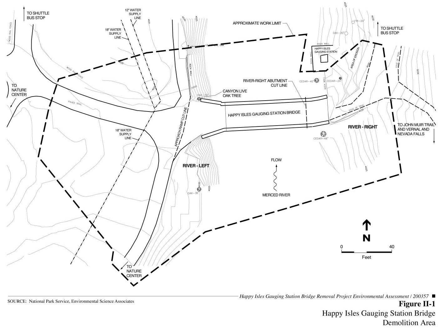
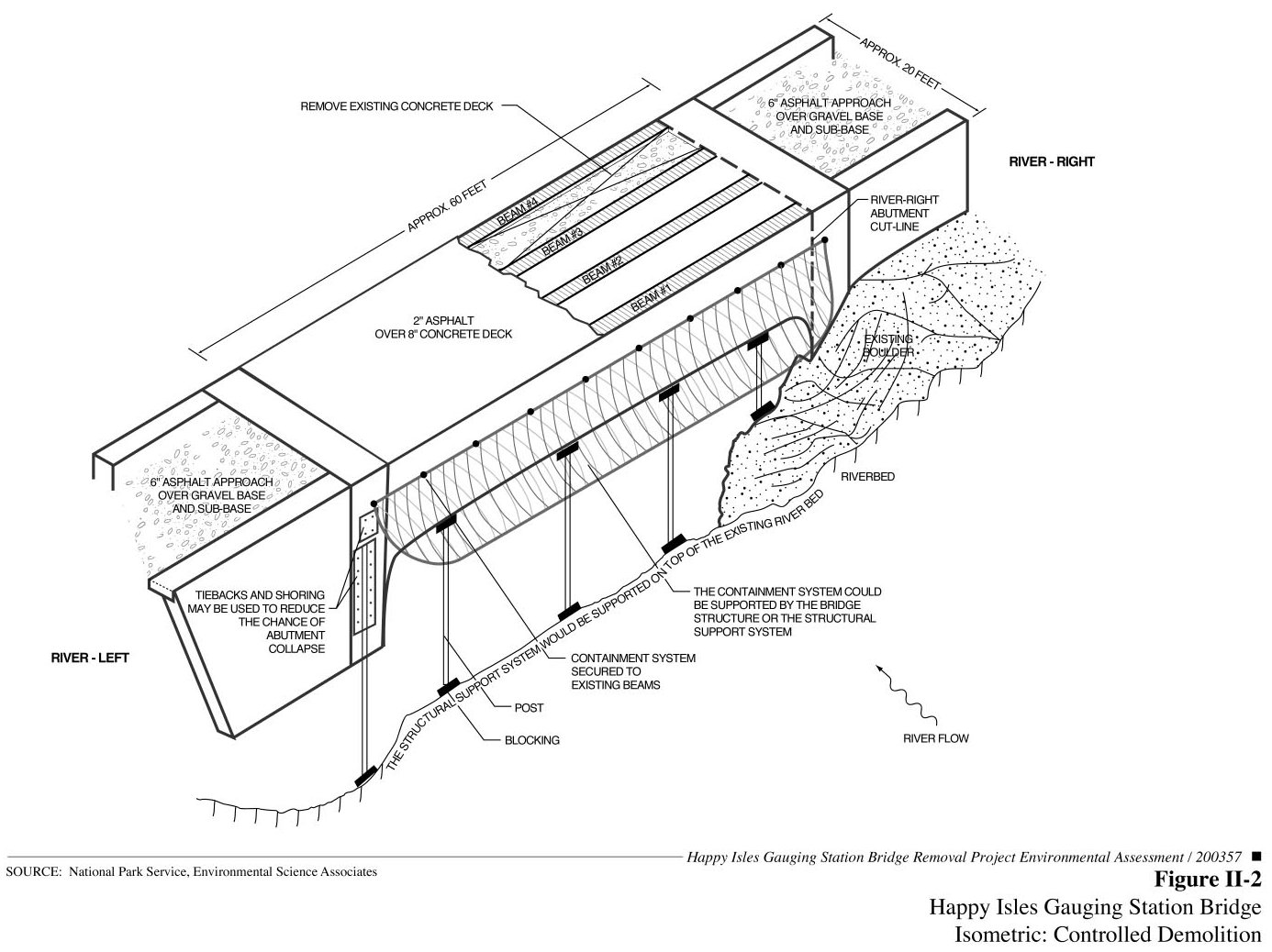
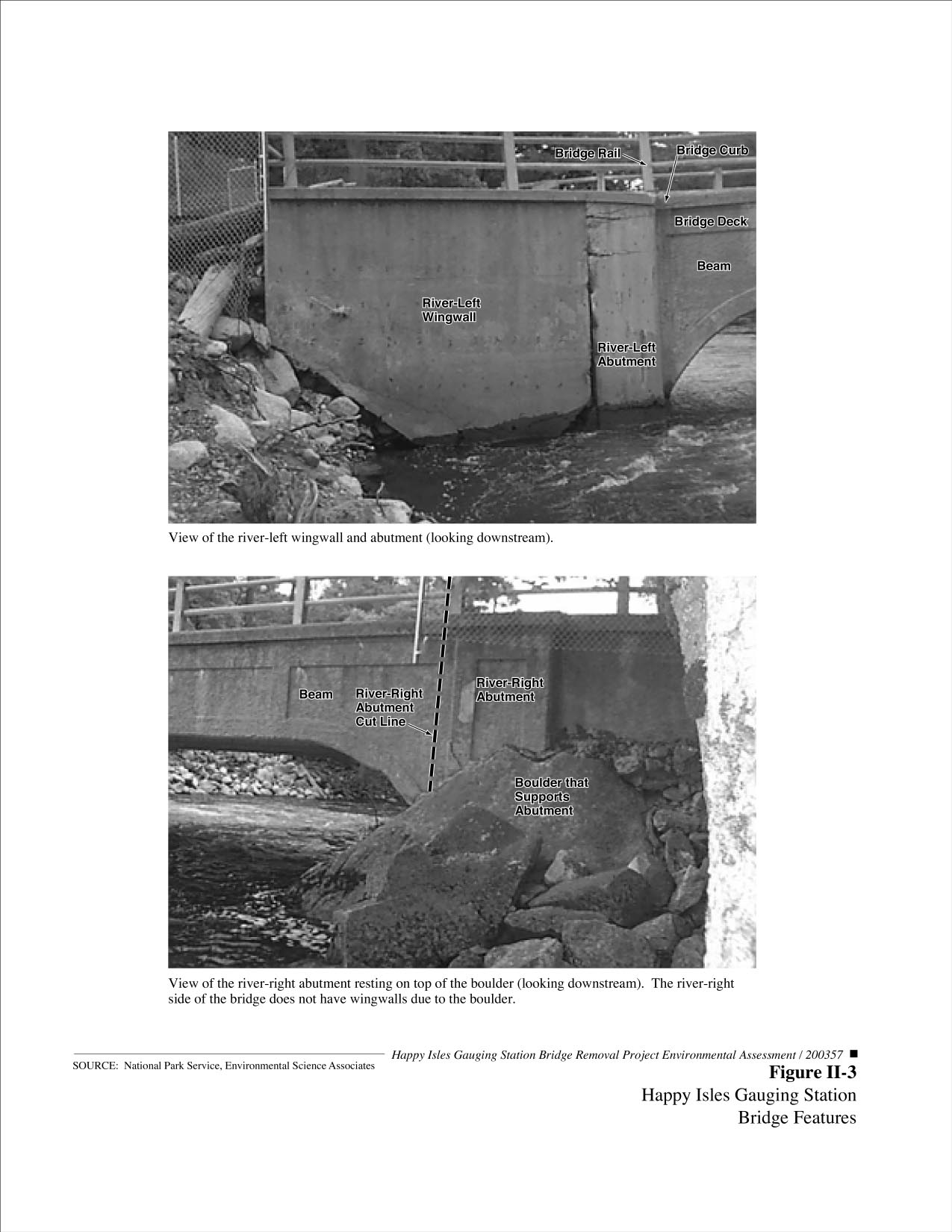
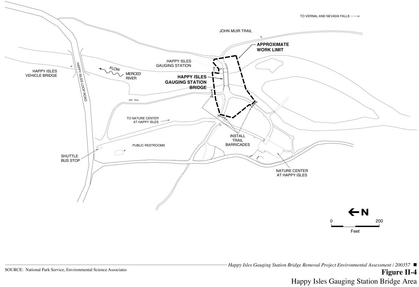
OverviewThe Controlled Demolition Alternative would involve separating the bridge span into liftable segments and removing them by a crane or excavator located on the riverbank within the approximate work limit (see figure II-1). A containment system (such as a reinforced tarp, netting, cage, or floating barge) would be installed beneath the Happy Isles Gauging Station Bridge to catch small amounts of debris during partial bridge removal. This containment system would prevent slurry from concrete saws, as well as small debris, from falling into the Merced River. However, not all demolition debris would be prevented from falling into the river; masonry debris greater than 2 inches in any dimension and all metal debris that inadvertently fall into the river would be removed. A structural support system (such as scaffolding, jacks, or mechanical lifts) may be temporarily installed to prevent the uncontrolled collapse of the bridge structure during demolition. It is not yet known whether a structural support system will be necessary during demolition, however, to be conservative, this alternative considers such a system (see figure II-2). Under this alternative, controlled demolition techniques would be used to minimize, to the extent possible, disturbance to the Merced River. The features of the Happy Isles Gauging Station Bridge are labeled in the photographs in figure II-3. Partial Bridge DemolitionThe Controlled Demolition Alternative would include the measures described below. Several different types of construction equipment may be used in demolishing the bridge and are thus identified. Containment SystemA temporary containment system would be positioned beneath the Happy Isles Gauging Station Bridge to prevent small debris and slurry from concrete saws from entering the Merced River. The containment system would include either a reinforced tarp, netting, cage, or a floating barge. As the bridge is being separated into liftable segments, the containment system would capture slurry and small sections of concrete and steel to limit the amount of demolition material that falls into the river. The containment system may be anchored to the existing structure, or may be connected to a structural support system (described below). The containment system would not be embedded into the bed and banks of the river, nor would it be anchored to any surrounding vegetation. Structural Support SystemA temporary structural support system may be installed to prevent the uncontrolled collapse of the bridge structure during demolition or to anchor the containment system, should additional support for the containment system be needed in addition to anchoring it to the existing bridge. The structural support system would include either scaffolding, jacks, or mechanical lifts positioned on tracks. If utilized, the structural support system would rest on blocks on top of the existing riverbed, to avoid deep punctures into the riverbed. The supports would be placed at intervals beneath the bridge. Small wheeled or tracked equipment would be allowed to enter the river to assist in the placement of the structural support system or to remove demolition debris from the river. To protect the riverbank, this equipment would either be lifted from the riverbank by crane and placed on the riverbed, or would be driven on a ramp into the river. Demolition and Removal ActivitiesThe partial bridge demolition would involve removing the curbs, rails, and asphalt surface from the bridge deck, separating the bridge into liftable segments, and removing these segments by crane or other equipment located on the riverbank. Equipment that may be used in the partial bridge demolition includes: cranes, excavators, backhoes, skid steer loaders, trucks, graders, jack hammers, concrete saws, jacks, and cutting torches, etc. The bridge components would be separated into liftable segments, and lifted onto a truck to be removed from the park and taken to a recycling facility. Most of the construction work would occur at or above the ordinary high water mark (see Glossary), with the exception of the possible installation of the temporary structural support system. Minor amounts of dry concrete and mortar, soil, gravel, and demolition debris (dust and similar-sized material) may periodically wash into the river. These would be infrequent events of short duration. Demolition debris larger than 2 inches in any dimension and all metal debris that inadvertently falls into the river would be removed during demolition. Restoration ActivitiesOnce the river-left abutment has been removed, the existing void in the riverbank would remain. This void would be filled and shaped to match adjacent bank composition (boulders, cobbles, and gravels) and contour. The large size of substrate materials along this stretch of the river provides for bank stability. Riparian vegetation would be planted to match conditions of adjacent portions of the riverbank, but would not be relied upon to provide for bank stability along this steep gradient section of the river. The river-right abutment, which is anchored to a large boulder in the riverbank, would be retained to protect the historic Happy Isles Gauging Station. The top of the river-right abutment would be converted to a river-viewing platform. The area eroded by the 1997 flood immediately downstream of the river-right abutment would be regraded to match adjacent natural bank contours and revegetated. Trees and vegetation at the site would be retained to the maximum extent practicable. The 30 inch-diameter canyon live oak tree adjacent to the river-left abutment would be retained, if possible. The canyon live oak tree is the only tree on this portion of the riverbank, contributes to riparian habitat by providing afternoon shade for this reach of the river, and provides woody debris to the river system. If removal of the wingwall undermines the major structural roots of the oak tree, then the National Park Service would re-evaluate removal of the tree due to potential tree fall hazard. Should the tree be removed, the National Park Service would either cut and remove the tree from the site, cut and retain the tree to contribute woody debris to the river, or destabilize and control the fall of the tree to retain woody debris and a natural-appearing fallen tree with the root ball attached. Such activities would occur subsequent to bridge demolition. Bridge demolition work would be completed within a two-month period when the river is at low flow. The approximate cost of the Controlled Demolition Alternative ranges between $200,000 and $300,000. As previously noted, the Controlled Demolition Alternative allows for a range of construction equipment to be used during demolition. However, helicopters and skycranes would not be used to remove the bridge, nor would explosives or blasting be used. Other Elements of the Controlled Demolition AlternativeMerced Wild and Scenic River Management Plan ElementsBecause the Happy Isles Gauging Station Bridge is located on the main stem of the Merced River, Alternative 2 must comply with the management elements prescribed in the Merced Wild and Scenic River Comprehensive Management Plan (Merced River Plan). The management elements include: boundaries, classifications, Outstandingly Remarkable Values, Wild and Scenic Rivers Act Section 7 determination process, River Protection Overlay, management zoning, and implementation of a Visitor Experience and Resource Protection framework. Chapter V, Merced Wild and Scenic River, discusses the consistency of the proposed action with the Merced Wild and Scenic River Comprehensive Management Plan management elements. The Wild and Scenic Rivers Act Section 7 determination is included in Appendix C. General Site Access and Construction StagingHappy Isles Gauging Station Bridge is located
in east Yosemite Valley, near the Nature Center at Happy Isles.
Construction access to the site would be provided via the pedestrian
pathway on the river-right side of the bridge. The 12-foot-wide paved
pedestrian walkway between the shuttle bus stop and the Nature Center
at Happy Isles would be used to access the work site on the river-left
side of the bridge (see figure II-4). Temporary pedestrian delays of
up to 30 minutes would be allowed to ensure the safe movement of
trucks and heavy equipment into and out of the work area. Flag persons
would assist visitor movements as necessary to ensure visitor safety.
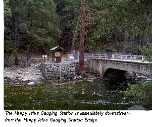
Trail barricades would be posted at three locations to prevent visitor movements into the work area. The perimeter of the work area would be delineated with warning signs (see figure II-4). Construction staging would be located within the delineated work area. Happy Isles Gauging Station The
river-right abutment, which is located on a large boulder on the
riverbank, would be retained to protect the historic Happy Isles
Gauging Station and streamflow gauge.
The cut line (the line along
which the abutment would be separated from the bridge) for the
river-right abutment is shown in figure II-3.
Downstream Debris CatchmentAlternative 2 would incorporate a down-stream catchment net to capture construction debris in the Merced River that is not collected at the demolition site. Material DisposalNo disposal of bridge materials (including concrete and metal) would occur within the boundaries of Yosemite National Park. Materials would be properly disposed of at an approved recycling facility. Demolition TimingThe U.S. Army Corps of Engineers requires that demolition activities occur during low water months.[1] In-channel activities therefore would take place during the fall of 2001, when flow of the Merced River is expected to be less than 200 cubic feet per second (approximately 95% of the time). Bridge demolition would be avoided during higher flow periods. Permit ComplianceAll demolition activities within the river channel would conform with applicable provisions of the Clean Water Act and with state and local regulations concerning sediment releases, turbidity, and prevention of water pollution. Best Management Practices (as identified below in the Action Alternatives Mitigation Measures section) would be required to control erosion within the work site, and to prevent potential contamination of water due to the operation of heavy construction equipment. All permit requirements would be met. RecyclingConsistent with the National Park Service Guiding Principles of Sustainable Design (1993), a requirement for recycling of the demolition material would be included in construction contracts. Alternatives Considered but Dismissed Complete Removal of Happy Isles Gauging Station BridgeThe National Park Service considered complete removal of Happy Isles Gauging Station Bridge, including the river-right abutment. This alternative was considered but dismissed due to the possible risk of damage to the historic Happy Isles Gauging Station and streamflow gauge. Although there is a large boulder directly upstream of the gauging station, National Park Service hydrologists do not believe that the boulder will provide sufficient protection to the gauging station during periods of high flows and flood events. The river-right abutment of the Happy Isles Gauging Station Bridge, which is located on the large boulder immediately upstream from the gauging station, provides additional protection to the Happy Isles Gauging Station and streamflow gauge during high flows and flood events. The Happy Isles Gauging Station, a historic resource and contributing feature to the Yosemite Valley Cultural Landscape, has continuously recorded streamflow data since 1915. To avoid damage to or loss of the gauging station, the National Park Service determined that the river-right abutment of Happy Isles Gauging Station Bridge should not be removed so that it could continue to protect the gauging station and streamflow gauge during high flows and flood events. Thus, complete removal of the Happy Isles Gauging Station Bridge was considered but dismissed. The National Park Service is considering relocation of the Happy Isles Gauging Station and streamflow gauge to the river-left bank of the Merced River. This project is identified as a cumulative project, discussed in Appendix A, and would be addressed in a separate planning document. Repair of Happy Isles Gauging Station BridgeThe National Park Service considered repairing the Happy Isles Gauging Station Bridge, but determined the condition of the bridge rendered repair too uncertain and extended a process to prevent the collapse of the bridge, which is considered imminent. The January 1997 flood caused severe scour, with full-length undermining of the bridge, loss of support to the river-left abutment, and subsequent settlement of the bridge deck. The National Park Service in consultation with the Federal Highway Administration determined that the existing bridge structure has been weakened and compromised in the vicinity of the river-left abutment due to the extent of concrete cracking, crushing, and displacement evidenced by the bridge. Damage to the bridge is sufficiently extensive such that any attempted repair scenario would require complete removal and replacement of the concrete for the entire west abutment, wingwalls, and a portion of the affected superstructure. The National Park Service further determined that repair of the bridge would require extensive bank armoring to protect the structure from further erosion. The consequent hazards to public health and safety and adverse impacts to natural resources resulting from potential collapse of the bridge are considered too severe such that repair is not reasonable within the expedited time frame under which the National Park Service would like to address the collapsing bridge. Therefore, repair of the bridge has been eliminated from detailed consideration as a reasonable alternative in this Environmental Assessment. Uncontrolled Demolition of the Happy Isles Gauging Station BridgeThe National
Park Service considered uncontrolled demolition of the Happy Isles
Gauging Station Bridge which would involve the use of a crane with a
wrecking ball to demolish the structure. Large blocks of concrete and
other demolition material would be allowed to fall into the river.
These blocks of material also would spall concrete as it broke from
the girders, causing more debris to fall into the river. Large
demolition debris would be retrieved using a clamshell excavator. This
alternative was dismissed from further consideration because it would
not take measures to prevent demolition material from falling into the
Merced River, and it would not allow for protection of the river-right
abutment during removal. Large pieces of demolition material would
need to be excavated from the riverbed, which could adversely affect
the Happy Isles Gauging Station pool directly downstream. In addition,
in the absence of a debris catchment system, substantial amounts of
small-sized demolition debris (less than half a cubic foot) would
enter the river and could be carried downstream before it could be
retrieved. Action Alternative Mitigation Measures To ensure that implementation of the action alternative protects natural and cultural resources, and the free-flowing condition of the Merced River, a consistent set of mitigation measures would be applied to the alternative. As part of the environmental review, the National Park Service would avoid, minimize, and mitigate impacts when practicable. Sustainable Design and AestheticsThe project shall avoid or minimize impacts to natural and cultural resources. The project shall be designed to work in harmony with the surroundings, particularly the Yosemite Valley Cultural Landscape. The project shall reduce, minimize, or eliminate air and water nonpoint-source pollution. The project shall be sustainable whenever practicable, by recycling and reusing materials, by minimizing materials, and by minimizing energy consumption during the project. Best Management Practices During DemolitionBest Management Practices shall be implemented, as appropriate, prior to, during, and/or after project demolition. Specific tasks shall include, but are not limited to, the following: · The National Park Service project manager shall make inspections to ensure that the extent of impacts stay within the parameters of the project so they do not escalate beyond the scope of the environmental assessment, as well as to ensure that the project conforms with the U.S. Army Corps of Engineers Section 404 permits. The National Park Service project manager shall oversee that mitigation measures are followed. · Implement a natural resource protection program. Standard measures include pre-construction briefing of natural and cultural resource protection measures, construction scheduling, erosion and sediment control, use of fencing or other means to protect resources adjacent to the project area, salvage of native materials (rock, cobbles, gravels, plants, soil, litter, and duff) and reuse on the site to minimize the need to import non-native materials, removal of all food-related items or rubbish to bear-proof containers, and regrading and revegetation. Food shall be stored in accordance with park regulations. · Small wheeled or tracked equipment would be allowed to enter the river to assist in the placement of the structural support system or to remove demolition debris from the river. To protect the riverbank, this equipment shall be lifted from the riverbank by crane and placed on the riverbed, or shall be driven on a ramp into the river. Heavy equipment used within the bed and banks of the Merced River should be placed on mats, or other measures would be taken to minimize disturbance. · Masonry debris greater than 2 inches in any dimension and all metal debris that inadvertently falls into the river shall be removed during demolition. ·
If deemed necessary,
demolition work on weekends or federal government holidays may be
authorized, with prior written approval of the Superintendent. To the
extent possible, all on-site noisy construction work above 76 dba
(such as the operation of heavy equipment) shall be done between the
hours of 8:30 a.m. and 5:00 p.m. to minimize disruption to nearby
campers. · Implement a dust abatement program. Construction contractors shall implement the following measures: - Water all active work areas, access roads and paths, parking areas, and staging areas at least twice daily (use of dust abatement products would not be allowed). Ensure that applied water does not enter the Merced River. - Cover all trucks hauling demolition debris and other loose materials that could spill onto paved surfaces, or require all trucks to maintain adequate freeboard. - All paved areas that are subject to vehicular and pedestrian traffic shall be kept clean of construction debris and soils. Sweeping of these areas will be implemented as necessary. - Cover all stockpiles. - Limit traffic speeds on unpaved roads and paths to 5 miles per hour. - Revegetate disturbed areas, if appropriate, upon completion of the project. · Implement vehicle emissions controls. Construction contractors shall implement the following measures: - Use California on-road diesel fuel for all diesel-powered construction equipment. - Use construction equipment that is properly tuned and maintained in accordance with manufacturers’ specifications. -
Use best management
construction practices to avoid unnecessary emissions (e.g., engines
of trucks and vehicles in loading and unloading areas would be turned
off when not in use). · All construction equipment shall be equipped with mufflers kept in proper operating conditions, and when possible, equipment shall be shut-off rather than allowed to idle. Standard noise abatement measures include the following elements: a schedule that minimizes impacts to adjacent noise-sensitive uses (campgrounds, etc.) between 8:30 a.m. and 5:00 p.m., use of the best available noise control techniques wherever feasible, use of hydraulically or electrically powered impact tools when feasible, and location of stationary noise sources as far from sensitive public use areas as possible. Trucks and other construction equipment shall be equipped with standard muffling devices and shall not be excessively loud. · Heavy equipment shall be steam cleaned prior to entering the park to prevent importation of non-native plant species, and repaired of all petroleum leaks prior to working near the Merced River. Hydraulic hoses shall be fastened tight and shall be in good condition. · Ensure that the spread of non-native plant species is controlled. Standard measures include the following elements: ensure construction-related equipment arrives on site free of mud or seed-bearing material, certify all seeds and cover material as weed-free, identify nearby areas of non-native vegetation before construction, avoid spreading non-native vegetation within the project area, and revegetate with appropriate native species. · To minimize the possibility of hazardous materials seeping into soil, or water, equipment shall be checked frequently to identify and repair any leaks. Standard measures include hazardous materials storage and handling procedures; spill containment, cleanup, and reporting procedures; and limitation of refueling and other hazardous activities to upland/nonsensitive sites. An adequate hydrocarbon spill containment system (e.g., floatable absorption boom, absorption materials, etc.) shall be available on site, in case of unexpected spills in the project area. All equipment allowed within the river channel shall be equipped with a hazardous spill containment kit. · All construction equipment shall be stored within the delineated work limits. Excavated and stored materials will be located within the upland staging area and contained and stabilized to prevent reentry into the river. ·
Implement measures to
reduce effects of demolition on visitor safety and experience.
Visitors, contractors, and park personnel shall be safeguarded from
demolition activities. A barrier plan indicating locations and types
of barricades shall be used to protect public health and safety. · Ensure an emergency notification program is in place. Standard measures include notification of utilities and emergency response units prior to demolition activities. Locations of existing utilities shall be identified prior to demolition activity to prevent damage to utilities, particularly the water supply lines that pass through the work limits. The contractor shall call Underground Services Alert and National Park Service maintenance staff 72 hours prior to any ground disturbance. Demolition shall not proceed until the process of locating existing utilities is completed. To avoid damage to underground water supply lines located beneath the service road east of the restrooms, heavy equipment shall access the river-left demolition area via the service road located west of the restrooms. Because impacts to the existing 8-inch drainage pipe (which is connected to the 12-inch water line) could damage the existing water line, measures shall be taken to avoid such impacts. Measures shall include protection of this line from being struck or disturbed during the demolition and any associated grading. · Avoid damage to natural surroundings in and around the work limits. Provide temporary barriers to protect existing trees, plants, and root zones, if necessary. Trees and other vegetation would not be removed, injured, or destroyed without prior written approval. Ropes, cables, or fencing would not be fastened to trees. All existing resource protection fencing (post and rope) shall be left in place and protected from heavy equipment. · All tools, equipment, barricades, signs, surplus materials, and rubbish shall be removed from the project work limits upon project completion. Any asphalt surfaces that are damaged due to work on the project shall be repaired to original condition. All demolition debris shall be removed from the project site, including all visible concrete and metal pieces. Disturbed areas shall be graded and raked smooth to eliminate tire tracks and tripping hazards. Resource-Specific MeasuresGeology , Geohazards , and Soils· Provide erosion and sediment control. Hydrology , Water Quality , and Floodplains· Implement stormwater management measures as necessary to reduce nonpoint- and point-source pollution discharge from paved and other impervious surfaces. This could include street sweeping, and use of permeable surfaces and vegetated or natural filters to trap or filter stormwater runoff. Wetlands· Minimize adverse effects to aquatic resources in accordance with Executive Order 11990 (Protection of Wetlands), the Clean Water Act, and Director’s Order #77-1. The National Park Service project manager will be responsible for obtaining applicable aquatic resource-related permits and approvals and will ensure project compliance with all stipulations. · Monitor area to ensure success of bank restoration and stability. Vegetation· Avoid impacts to vegetative communities and trees. If avoidance is not feasible, written permission from the National Park Service project manager must be granted before proceeding. · Use only native plants in revegetation. · Comply with the Yosemite Vegetation Management Plan (NPS 1997g) for revegetation within and around the project work site. Wildlife and Special-Status Species· Implement measures to reduce bear/human encounters (i.e., proper food storage). · Educate workers on the dangers of intentional or unintentional feeding of park wildlife, and on inadvertent harassment through observation or pursuit. · Minimize night lighting during construction. Where night lighting is necessary, design lighting to be minimal, directed downward, and shielded. · Excavation sites (trenches or pits) would have suitable ramps to allow all small mammals to exit these areas. Special-Status Birds· To avoid conflicts with nesting birds, construction activities within nesting habitat should occur outside the breeding season (typically March to August). · If it is determined that the action will not impact an active nest or disrupt breeding behavior, construction will proceed without any restriction or mitigation measure. · If it is determined that construction will impact an active nest or disrupt reproductive behavior then avoidance strategies should be implemented. Construction could be delayed within 500 feet of such a nest until a qualified biologist determines, in consultation with National Park Service wildlife biologists, that the subject birds are not nesting or until any juvenile birds are no longer using the nest as their primary day and night roost. Special-Status Aquatic SpeciesImplementation of the following conservation and protection measures would reduce or eliminate potential taking of special-status aquatic species. · Work activities within potential special-status aquatic species habitat should be completed during low-flow conditions. · The aquatic construction boundary should be fenced to prohibit to control siltation and disturbance to aquatic habitat. · All construction adjacent to or within aquatic habitats should be regularly monitored. · All fueling and maintenance of vehicles and equipment should occur at least 20 meters (65 feet) from any aquatic habitat. Cultural Resources· Ensure cultural resources within and adjacent to the project area are protected. Standard measures include use of fencing or other means to protect cultural resources adjacent to demolition. This task includes specific demolition monitoring by resource specialists, as well as treatment and reporting procedures. · Conduct bridge demolition in accordance with the park’s 1999 Programmatic Agreement and stipulations of the Yosemite Valley Plan. Standard mitigation measures include recordation, salvage, and interpretation. Efforts shall be made to reduce impacts through use of the Secretary of the Interior’s Standards for Archeology and Historic Preservation. · Consult with the State Historic Preservation Officer on the bridge removal in that it is an adverse action to a historic resource eligible for listing on the National Register of Historic Places. Scenic Resources· Avoid or minimize adverse effects on natural communities and visual intrusion into the natural landscape. Summary of Environmental ConsequencesTable II-1 summarizes the key impacts that could result from each of the alternatives, including the No Action Alternative. Detailed descriptions of these impacts are provided in Chapter IV. Alternative 1: No ActionUnder the No Action Alternative, Happy Isles Gauging Station Bridge would continue to degrade and would eventually fail. Bridge collapse would likely occur during high flow conditions. Bridge-related debris would be deposited downstream, possibly damaging the historic Happy Isles Gauging Station and disrupting the validity of measurements from the gauging station pool. Deposition of bridge-related debris would also adversely affect natural, cultural, and scenic resources and recreation. Sudden collapse of the bridge could result in serious injuries and/or fatalities to recreational users of the river. The National Park Service would remove bridge debris from the river as soon as possible following bridge collapse, although the retrieval effort may be delayed by several months, since debris removal activities would need to occur during periods of low flow. Diverted river flows and erosion could result in adverse impacts to vegetation, soils, and cultural resources along the riverbanks. Over the long term, uncontrolled failure of the bridge largely would enhance free flow of the Merced River at this location. Alternative 2: Controlled DemolitionRemoval of Happy Isles Gauging Station Bridge would have short-term demolition-related impacts on natural, cultural, and social resources. Because demolition would occur in a controlled manner (e.g., within a delineated work area, during low-flow conditions, with the application of Best Management Practices), Alternative 2 would avoid the more pronounced adverse effects of uncontrolled bridge failure and debris retrieval activities described under Alternative 1. Demolition-related impacts would be reduced by application of Best Management Practices and resource-specific mitigation measures. Minor regrading and revegetation would increase bank integrity resulting in beneficial effects on soils, water quality, cultural resources, and biological resources. Similar to Alternative 1, controlled bridge removal largely would enhance the free-flowing condition of the Merced River and return this portion of the river to a more natural condition, thereby enhancing its biological and hydrologic integrity. Alternative 2 would have a long-term, beneficial effect on natural and scenic resources because it would return a portion of the riverbank to a more natural state (benefiting wetland and aquatic resources), enhance the active flood regime and fluvial processes, and improve views from the riverbank. Environmentally Preferable AlternativeThe CEQ Regulations implementing the National Environmental Policy Act (NEPA) and the National Park Service NEPA guidelines require that “the alternative or alternatives which were considered to be environmentally preferable” be identified (CEQ Regulations, Section 1505.2). Environmentally preferable is defined as “the alternative that will promote the national environmental policy as expressed in the National Environmental Policy Act’s Section 101. Ordinarily, this means the alternative that causes the least damage to the biological and physical environment; it also means the alternative that best protects, preserves, and enhances historic, cultural, and natural resources” (“Forty Most Asked Questions Concerning Council on Environmental Quality’s [CEQ] National Environmental Policy Act Regulations,” 1981). Section 101 of the National Environmental Policy Act states that “… it is the continuing responsibility of the Federal Government to … (1) fulfill the responsibilities of each generation as trustee of the environment for succeeding generations; (2) assure for all Americans safe, healthful, productive, and aesthetically and culturally pleasing surroundings; (3) attain the widest range of beneficial uses of the environment without degradation, risk to health or safety, or other undesirable and unintended consequences; (4) preserve important historic, cultural, and natural aspects of our national heritage, and maintain, wherever possible, an environment which supports diversity, and variety of individual choice; (5) achieve a balance between population and resource use which will permit high standards of living and a wide sharing of life’s amenities; and (6) enhance the quality of renewable resources and approach the maximum attainable recycling of depletable resources.” The environmentally preferable alternative for the Happy Isles Gauging Station Bridge Removal Project is based on these national environmental policy goals. Alternative 1: No ActionThe No Action Alternative represents conditions and management practices as they currently exist for the Happy Isles Gauging Station Bridge. The provision of productive, and aesthetically and culturally pleasing surroundings (provision 2 of the national environmental policy goals) would be adversely affected due to uncontrolled collapse of the bridge that would result in visually intrusive bank erosion and debris within the channel of the Merced River, and endanger the Happy Isles Gauging Station and other sensitive cultural resources in the vicinity. Alternative 1 would not fulfill provision 3 of the national environmental policy goals because risks to public health and safety would worsen under this alternative due to the uncontrolled failure of the bridge. Alternative 1 would not preserve natural resources as required under provision 4 of the national environmental policy goals. Eventual bridge failure would lead to sudden bank erosion that would affect soils, water quality, and biological resources such as vegetation and special-status species. Alternative 2: Controlled DemolitionAlternative 2 includes controlled demolition and partial removal of the Happy Isles Gauging Station Bridge. Because demolition would occur in a controlled manner (e.g., within a delineated work area, during low-flow conditions, with the application of Best Management Practices), Alternative 2 would avoid the more pronounced adverse effects of uncontrolled bridge failure and debris retrieval activities described under Alternative 1. The application of mitigation measures described in Chapter II would further reduce the potential adverse impacts. The provision of aesthetically pleasing surroundings (provision 2 of the national environmental policy goals) would be improved because of the inclusion of site restoration. Alternative 2 would fulfill provision 3 of the national environmental policy goals by reducing risks to public health and safety through the controlled demolition of the bridge and application of mitigation measures to reduce hazards to visitors. Alternative 2 would preserve natural and cultural resources as required under provision 4 of the national environmental policy goals. This alternative would implement measures to reduce adverse effects related to demolition activities (e.g., Best Management Practices) and includes site restoration to increase site stability and biological integrity. Alternative 2 also would ensure protection of the Happy Isles Gauging Station and other sensitive cultural resources in the vicinity by removing the bridge in a controlled manner and avoiding the adverse effects of bank erosion that would occur under Alternative 1. Environmentally Preferable AlternativeThe environmentally preferable alternative is Alternative 2 because, of the alternatives considered in detail, it most fully satisfies the national environmental policy goals stated in Section 101 of the National Environmental Policy Act. Alternative 2 would (1) provide a high level of protection of natural and cultural resources while concurrently attaining the widest range of beneficial uses of the environment without degradation; (2) reduce risks to public health and safety; and (3) provide an aesthetically pleasing surrounding. TABLE
II-1: Summary of Environmental Consequences
[1] Activities on the main channel of the Merced River would be subject to jurisdiction under Section 404 of the Clean Water Act by the U.S. Army Corps of Engineers as nonwetland waters of the United States.
|
||||||||||||||||||||||||||||||||||||||||||||||||||||||||||||||||||||||||||||||||||||||||||||||||
Main . Table of Contents . Abstract . Executive Summary . Scoping Summary . Fact Sheet . Superintendent's Letter . Environmental Assessment . FONSI
