

|
|
Fact Sheet
___________________________________________
Happy Isles Gauging Station Bridge Removal
 Background
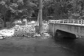
The bridge is a cast-in-place, all-concrete structure, initially used by vehicles. Prior to the 1997 flood, its primary use was to provide pedestrian access to the John Muir and Mist Trails.
What is the bridge?
The
Happy Isles Gauging Station Bridge, which spans the Merced Wild and Scenic River
in Yosemite Valley’s east end, was constructed in 1921. The bridge is eligible
for listing on the National Register of Historic Places and is a contributing
element within the Yosemite Valley Cultural Landscape. Located near the Nature
Center at Happy Isles, the bridge crosses the river at the location of one of
the Sierra Nevada’s most prominent trailheads—the 211-mile John Muir Trail.
Millions of visitors also use this departure point to access the Mist Trail up
to Vernal and Nevada Falls in Yosemite.
Why remove the bridge?
The
bridge was badly damaged during the 1997 flood and was deemed unsafe by
representatives of the Federal Highways Administration. Based on these findings,
it was condemned for safety reasons in July 1997. Since that time, the bridge
has continued to deteriorate and is showing signs of
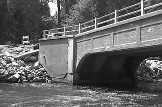
immediate failure with a large sinkhole appearing on the west abutment.
The loss of support under the west abutment is causing the structure to
“hang” from the west wingwalls, introducing stresses for which the bridge
was not designed. The west abutment area is also cracking and crumbling,
indicating severe failure and eminent collapse of the structure.
Due
to the threat to public health and safety, the bridge should be removed
immediately—before it collapses on its own accord. The east abutment will be
retained in order to protect the operational stream flow gauge. This gauge may
eventually be moved to the west side of the river, however this relocation would
be treated as a separate project in the future.
What are the alternatives?
The
Happy Isles Gauging Station Bridge Removal Project Environmental Assessment
presents two alternatives. Alternative 1 (the No Action Alternative) constitutes
an approach of benign neglect, allowing the bridge to deteriorate over time.
(However, it is acknowledged that this would pose a significant public health
and safety hazard.)
Alternative
2 (the Preferred Alternative) involves “controlled demolition” whereby the
bridge span would be separated into liftable segments and then removed by crane
or excavator from within the bed and banks of the river. A containment system
(netting, cage, reinforced tarp, or floating barge) would be installed beneath
the bridge to catch small amounts of debris. The river-right abutment would
remain to allow continued use of the historic Happy Isles Gauging Station.
Will the bridge be replaced?
A replacement bridge will be constructed in the future as described in the Yosemite Valley Plan.
 What
are the key resource concerns?
What
are the key resource concerns?
If
the bridge is not removed, the risk of it experiencing an uncontrolled collapse
during a period of high water remains great. If this were to occur, the
collapsed structure could create an unnatural dam in the river, causing
uncontrolled erosion to both banks.
This is similar to what happened during the 1997 flood, when a build-up of
natural debris on the bridge itself caused floodwaters to flow around the
abutments, cutting into the streambanks on either side. An uncontrolled collapse
could also endanger the John Muir Trailhead as well as the existing water supply
line, which runs parallel to the river along the western bank under the existing
path.
Millions
come to Happy Isles each year to visit the Nature Center, to enjoy walks through
the small isles, and to photograph the spectacular views of the river and
surrounding granite domes and cliffs. The area is also a major departure point
for hikers and backpackers on their way to Vernal and Nevada Falls, Half Dome,
and beyond to the wilderness.
Removal
of the bridge is not expected change or re-direct stream flows or exacerbate
existing erosion patterns. Its removal would not effect the Merced River’s
Wild and Scenic River status; the bridge removal would follow the management
guidelines established in the Merced
River Plan, in accordance with the Wild and Scenic Rivers Act.
When will removal occur?
The proposed action will eliminate an immediate safety hazard while protecting the operational stream flow gauge. Demolition will need to be performed during the low water months of September, October, and November as required by the U.S. Army Corps of Engineers. Pending the approval of the project, demolition is anticipated to begin in late fall of 2001.
How can the public remain involved?
Public participation in the planning process is critical. Here are some ways to stay involved in the Happy Isles Gauging Station Bridge Removal Project:
Mail:
Superintendent
Attn: Happy Isles Gauging
Station Bridge Removal Project
National Park Service
P.O. Box 577
Yosemite, CA 95389
Fax: 209/372-0456
Email: YOSE_Planning@nps.gov
___________________________________
Main . Table of Contents . Abstract . Executive Summary . Scoping Summary . Fact Sheet . Superintendent's Letter . Environmental Assessment