

|
|
|
I. Purpose and NeedBackgroundHistory of the Happy Isles Gauging Station Bridge
The bridge may be eligible for addition to the National Register of Historic Places and is listed as a contributing element of the Yosemite Valley Cultural Landscape. In 1991, it was studied and recorded as part of the Historic American Engineering Record. In July 1996, a massive rockfall and windblast in the Happy Isles area damaged the bridge. Then in January 1997, a major flood caused extensive damage to structures along the main stem of the Merced River, including the Happy Isles Gauging Station Bridge. The flood caused severe scouring that undermined the full length of the river-left abutment. The loss of support under the river-left abutment caused the bridge structure to hang from the river-left wingwalls, introducing stresses for which the bridge was not designed. The concrete in the river-left abutment area showed signs of cracking and crushing, indicating failure of the structure. The bridge was
inspected by the Federal Highway Administration on July 22 and 23, 1997.
The Federal Highway Administration identified that the bridge was
damaged due to the scour caused by the January 1997 flood. The
administration also indicated that total collapse of
Happy Isles Gauging StationThe
Happy Isles Gauging Station, operated by the United States Geological
Survey, is located on the river-right bank of the Merced River
immediately downstream of the Happy Isles Gauging Station Bridge. The
first station in this location was a staff gauge (see Glossary)
installed in August 1915. This gauge was replaced in November 1916 by an
automatic water-stage recorder (see Glossary) (NPS 1999b). The Happy
Isles Gauging Station has been in continuous operation since 1915 and
has produced the longest continuous record of streamflow data available
anywhere in California. It is considered one of the 49 benchmark gauges
in the United States used as a standard to measure changes in the
environment. The gauging station also acts as an early warning system
for floods in Yosemite Valley. The National Park Service would protect
this gauging station during bridge removal. A
large boulder (on the river-right bank of the Merced River) and the
river-right bridge abutment (which is anchored to the large boulder)
protect the gauging station from damage during floods. Although the
bridge was not built for this purpose, protection of the gauging station
is an additional, unintended benefit of the Happy Isles Gauging Station
Bridge. In order to continue protecting the Happy Isles Gauging Station
from damage, the National Park Service plans to retain the river-right
abutment of the bridge as long as the gauging station is in its current
location. In the future, the National Park Service may relocate the
Happy Isles Gauging Station. This action is described in Appendix A as a
reasonably foreseeable future project. Organization of the Environmental AssessmentThe proposed action for the Happy Isles Gauging Station Bridge and its environmental assessment, which evaluates the potential impacts of bridge removal, are integrated in this document and will be referred to collectively as the Happy Isles Gauging Station Bridge Removal Project Environmental Assessment. The contents of this document are as follows: Chapter I: Purpose and NeedFollowing this background section, the first chapter includes a discussion of the project’s purpose and need, planning context, management goals, and issues and concerns. Chapter II: AlternativesThis
chapter presents the project alternatives
considered by the National Park
Service for the Happy Isles Gauging Station Bridge. A summary table
comparing the environmental consequences of the alternatives is provided
at the end of this chapter. Chapter III: Affected EnvironmentThis chapter provides an overview of the affected environment of the Happy Isles Gauging Station Bridge and its surroundings. This chapter looks at the existing condition of natural resources, cultural resources , and social resources. Chapter IV: Environmental ConsequencesThis chapter presents the analysis of the potential environmental impacts of each alternative. Supporting data are included as appendices. Chapter V: Merced Wild and Scenic RiverThis chapter analyzes the consistency of the proposed action with the management elements of the Merced Wild and Scenic River Comprehensive Management Plan. Chapter VI: Consultation and CoordinationThis chapter summarizes the process relied upon in preparing and reviewing this document. Chapter VII: List of Preparers and ReviewersThis chapter lists the names and qualifications of the persons who are primarily responsible for preparing and reviewing the document. Chapter VIII: GlossaryThis chapter defines the technical terms and acronyms used in this document. Chapter XI: BibliographyThis chapter lists the references cited in this document. Purpose of
and Need for the Project
Purpose of the Happy Isles Gauging Station Bridge Removal ProjectThe purpose of the Happy Isles Gauging Station Bridge Removal Project is to: · Protect visitor health and safety by eliminating the threat posed by the failing concrete bridge. · Protect park resources from localized flooding that could result from uncontrolled bridge collapse during a high water period. · Prevent the difficult and potentially dangerous removal of bridge debris from the river that would be required if the bridge collapsed. · Protect park infrastructure (e.g., the historic Happy Isles Gauging Station and Happy Isles Vehicle Bridge, as well as water supply lines) from possible damage due to uncontrolled bridge collapse by removing the bridge before it collapses of its own accord. · Protect Happy Isles Gauging Station from gauge calibration distortion caused by an uncontrolled bridge collapse. · Enhance the free-flowing condition of the Merced River. The primary purpose of the Happy Isles Gauging Station Bridge Removal Project is to protect public health and safety by removing the failing concrete bridge. The river-left abutment of the Happy Isles Gauging Station Bridge has been sufficiently undermined and the collapse of the bridge is imminent. Should the Happy Isles Gauging Station Bridge fail, the reinforced-concrete bridge would likely collapse in segments that would settle in place or wash downstream, potentially injuring park visitors and/or park staff nearby or downstream. Although the bridge is fenced off and access to it is prohibited, people occasionally climb the fence to cross the river or look at the bridge. In addition, this area is a popular location for swimming and wading. Removing the Happy Isles Gauging Station Bridge would enable the National Park Service to protect park visitors and staff from potential harm resulting from the uncontrolled collapse of the bridge or possible accidental injury while on or near the failing structure. The second purpose of the project is to protect park resources from localized flooding. Bridge collapse would likely occur during a period of high water flow. Collapse of the bridge could result in extensive erosion, as well as uncontrolled release of bridge debris into the Merced River. Large chunks of concrete, rebar, and other bridge materials could dam the river, divert the river from its channel, substantially erode the otherwise stable riverbanks in this area and result in localized flooding. Diverted river flows could also result in loss of vegetation along the riverbanks. Bridge debris could be deposited along the river channel and banks downstream to Happy Isles Vehicle Bridge and beyond. The third purpose of the project is to avoid the need for the difficult and potentially dangerous bridge removal activities that are likely to be required if the bridge collapses. If an uncontrolled collapse occurred, contractors would be obliged to conduct debris removal operations over an extended area in the river channel and on the riverbanks. Movement of heavy equipment in the channel and on the banks poses hazards to the equipment operators and resources. The fourth purpose of the project is to protect park infrastructure from possible damage from uncontrolled bridge collapse. Should the Happy Isles Gauging Station Bridge fail, large concrete segments of the bridge could damage nearby park infrastructure, including the historic Happy Isles Gauging Station or the historic Happy Isles Vehicle Bridge. In addition, should large concrete segments of the bridge collapse in place, river hydraulics would be altered. For example, river flows could erode the river-left bank, potentially threatening water supply lines located approximately 25 feet from the top of the bank. The fifth purpose of the project is to protect the historic Happy Isles Gauging Station. If an uncontrolled collapse occurred, pieces of the bridge settling in the large measuring pool could distort the calibration of the gauge, due to modified gauging station pool levels, river flows, and channel geometry. Damage to or loss of the Happy Isles Gauging Station would jeopardize the longest continuous recordation of streamflow data available anywhere in California. The final purpose of the project is to enhance the free-flowing condition of the Merced River by removing the damaged Happy Isles Gauging Station Bridge. Need for the Happy Isles Gauging Station Bridge Removal ProjectThe need for the proposed project arose as a result of the 1997 flood damage to the Happy Isles Gauging Station Bridge. Structural damage sustained by the bridge during the 1997 flood, as well as subsequent deterioration and structural failure (including a large sinkhole on the river-left abutment), have resulted in the need to remove the failing bridge before it collapses of its own accord. The National Park Service intends to remove the failing structure, which has been closed to the public since 1997. Initial and subsequent evaluations by the Federal Highway Administration in 1997, 1998, and 2001 (Federal Highway Administration letters are on file at Yosemite National Park) indicate that the bridge is in danger of collapse due to severe flood damage, and total collapse of the river-left side of the structure is imminent. The undermined river-left abutment and subsequent settlement have rendered the Happy Isles Gauging Station Bridge unsafe. Planning ContextRelationship to Yosemite National Park Plans
The
purpose of a general management plan
is to set a “clearly defined direction for resource preservation
and visitor use
” (NPS 1998b) and provide general
directions and policies to guide planning and management in the park.
The 1980 General Management Plan
is the overall planning document for
Yosemite National Park. The Merced Wild and Scenic River Com-prehensive Management Plan (Merced River Plan) is a planning document with weight equal to that of the General Management Plan. In designating the Merced River as a Wild and Scenic River, Congress authorized the National Park Service to prepare its management plan for the river by making appropriate revisions to the park’s 1980 General Management Plan (16 USC 1274[a][62]). The Merced River Plan provides a framework for decision-making on future management actions within the Merced Wild and Scenic River corridor. It applies seven management elements: boundaries, classifications, Outstandingly Remarkable Values, the Section 7 determination process, management zoning, the River Protection Overlay, and the Visitor Experience and Resource Protection framework. Implementation
plans, which tier off of the General
Management Plan
and Merced River Plan, focus on “how to implement an activity or
project needed to achieve a long-term goal” (NPS 1998b).
Implementation plans may direct specific projects as well as ongoing
management activities or programs and provide a more extensive level of
detail and analysis. The Yosemite Valley Plan outlines specific actions that will enable the
National Park Service to meet the General
Management Plan’s broad goals for Yosemite Valley and modifies
other provisions Regulations and PoliciesThe Happy
Isles Gauging Station Bridge Removal Project Environmental Assessment
is written within a complex set of regulations and policies. The
plan must not only comply with requirements of the National
Environmental Policy Act, but it must do so within the parameters
of other legislation that governs land use within Yosemite National Park
(see Appendix B). National Park Service Organic ActIn 1916, this act established the National Park Service in order to “promote and regulate the use of parks…” and defined the purpose of the national parks as “to conserve the scenery and natural and historic objects and wild life therein and to provide for the enjoyment of the same in such manner and by such means as will leave them unimpaired for the enjoyment of future generations.” This law provides overall guidance for the management of Yosemite National Park. The Prohibition on Impairment of Park Resources and ValuesThe Organic Act establishes the management responsibilities of the National Park Service. While Congress has given the National Park Service management discretion to allow certain impacts within parks, that discretion is limited by the statutory requirement that park resources and values be left unimpaired, unless a particular law directly and specifically provides otherwise. This cornerstone of the Organic Act establishes the primary responsibility of the National Park Service. It ensures that park resources and values will continue to exist in a condition that will allow the American people to have present and future opportunities for enjoyment of them. National Park Service Management Policies 2001 provides guidance on addressing impairment. Management GoalsManagement goals identify long-range direction for Yosemite National Park. Any proposed project must carefully balance multiple goals, especially in a park as large and complex as Yosemite National Park. This section presents the goals from Yosemite’s General Management Plan , the Merced Wild and Scenic River Comprehensive Management Plan, and Yosemite Valley Plan. General Management Plan
Goals
The General Management Plan for Yosemite National Park sets forth five broad goals for management of the park as a whole. The five broad goals include: · Reclaim priceless natural beauty · Allow natural processes to prevail · Promote visitor understanding and enjoyment · Markedly reduce traffic congestion · Reduce crowding Merced River Plan GoalsWhile the Merced Wild and Scenic River Comprehensive Management Plan works in concert with the goals set forth in the General Management Plan, it also outlines an additional set of goals for management of the Merced Wild and Scenic River. The main stem and South Fork of the Merced River were designated by Congress in 1987 for protection under the Wild and Scenic Rivers Act. The National Park Service developed the five goals of the Merced River Plan to further the policy established by the Wild and Scenic Rivers Act, namely to preserve designated rivers in their free-flowing condition, and protect and enhance a river’s Outstandingly Remarkable Values. The Merced River Plan goals include: · Protect and enhance river-related natural resources · Protect and restore natural hydrological and geomorphic processes · Protect and enhance river-related cultural resources · Provide diverse river-related recreational and educational experiences · Provide appropriate land uses The Merced River Plan applies seven management elements to prescribe desired future conditions, typical visitor activities and experiences, and park facilities and management activities allowed in the river corridor. The management elements as they relate to the Happy Isles Gauging Station Bridge are discussed in Chapter V, Merced Wild and Scenic River. The Wild and Scenic Rivers Act Section 7 determination is included in Appendix C. Yosemite Valley Plan GoalsThe Yosemite Valley Plan carries forward the goals of the General Management Plan. In addition, the Yosemite Valley Plan identifies four specific purposes of the plan. These include: · Restore, protect, and enhance the resources of Yosemite Valley · Provide opportunities for high-quality, resource-based visitor experiences · Reduce traffic congestion · Provide effective park operations, including employee housing, to meet the mission of the National Park Service The Yosemite Valley Plan also identifies criteria for accomplishing the broad goals of the 1980 General Management Plan in Yosemite Valley and the specific purposes of the Yosemite Valley Plan. The criteria include: · Protect and enhance natural and cultural resources · Enhance visitor experience · Provide effective operations · Provide appropriate land uses Issues and ConcernsThe following issues were identified during the public scoping process (see Chapter VI, Consultation and Coordination) and from National Park Service staff. The first set of issues, “Issues Addressed in the Happy Isles Gauging Station Bridge Removal Project Environmental Assessment,” includes only those that specifically relate to the proposed action. The second list, “Issues Not Addressed in the Happy Isles Gauging Station Bridge Removal Project Environmental Assessment,” includes issues that are addressed in other park plans and those that are beyond the scope of this project. Issues Addressed in the Happy Isles Gauging Station Bridge Removal Project Environmental AssessmentComponents of the AlternativesHappy Isles Gauging Station Bridge is a hazard that needs to be removed as soon as possible. The National Park Service recognizes that the Happy Isles Gauging Station Bridge is a failing structure that needs to be removed before it collapses of its own accord. The purpose of and need for the project specifically address this concern. Preserve the Happy Isles Gauging Station, as it provides important geologic information and history. The National Park Service recognizes the importance of continuing the uninterrupted recordation of streamflow data at Happy Isles Gauging Station. To ensure protection of the gauging station, the National Park Service proposes only partial removal of the Happy Isles Gauging Station Bridge, leaving the river-right abutment in place to continue to protect the gauging station. Natural ResourcesGeomorphology/Hydrology. Happy Isles Gauging Station Bridge has affected the natural river processes of the Merced River for over 80 years, influencing the shape and nature of the river. The bridge constricts the river especially during periods of high flow, resulting in scour and erosion of the river bed and bank. Fish, Wildlife, and Plant Habitat. The Merced River corridor supports diverse aquatic and riparian habitats for plant and wildlife species. Natural habitats at the bridge site have been altered by facilities and decades of human use, resulting in effects on plant and wildlife species. Removal of Happy Isles Gauging Station Bridge should be designed to improve the environment and not result in long-term, adverse effects to the Merced River. Water Quality. Bridge demolition has the potential to temporarily increase turbidity and decrease water quality of the Merced River. In addition, the analysis of alternatives considers the effects of possible hazardous materials releases in the Merced River. The project includes Best Management Practices to avoid or minimize such effects. Air Quality. Yosemite National Park is a Class 1 airshed (under the Clean Air Act) and therefore must maintain the highest standard of air quality . Demolition-related activity may temporarily affect local air quality. Cultural ResourcesHistoric Structures and Cultural Landscapes. Historically significant structures and landscapes exist throughout the Merced River corridor. The Happy Isles Gauging Station Bridge is a contributing element within the Yosemite Valley Cultural Landscape. Visitor ExperienceRecreation. Swimming, wading, sightseeing, photography, nature study, hiking, and stock use are among the recreational activities that exist in the area of the Happy Isles Gauging Station Bridge. These activities may be temporarily affected during demolition. Health
and Safety. The National
Park Service strives to protect visitors from natural hazards while
maintaining opportunities for high-quality visitor experience
s. Happy Isles Gauging Station Bridge
was closed in 1997 because it was deemed unsafe for public use.
Uncontrolled bridge collapse has the potential to affect downstream
resources (e.g., riparian habitats) and facilities (e.g., Happy Isles
Gauging Station), as well as to cause injuries to park visitors and
staff. Scenic Resources. The Merced River corridor offers beautiful views of the river and of the surrounding landscape. Removal of the bridge has the potential to affect the scenic interface of visual elements in the project area. Other Issues:
Planning Processes, Management, and Operations
Conflicts Between Protection of Natural Landscapes and Cultural Landscape s. Protection of one type of resource can sometimes require actions that are detrimental to the condition of others. For example, removal of Happy Isles Gauging Station Bridge will affect the Yosemite Valley Cultural Landscape by removing a contributing historic structure but will improve the free-flowing condition of the Merced River. Public Involvement. Comments and participation of the general public, local communities, visitors, park partners, and others are important in the formulation and refinement of this project. Cooperative, collaborative relationships with these parties will help ensure the protection and enhancement of the river corridor. Issues Not Addressed in the Happy Isles Gauging Station Bridge Removal Project Environmental AssessmentThe following issues are not addressed directly in the Happy Isles Gauging Station Bridge Removal Project Environmental Assessment for one of two reasons: (1) the issue is addressed by other plans, either completed or in progress; or (2) the issue is beyond the scope of this project. Replace the Happy Isles Gauging Station Bridge. Find a more suitable location for the bridge. This issue is beyond the scope of this project. Although the Yosemite Valley Plan calls for the replacement of the Happy Isles Gauging Station Bridge, the need to remove the bridge due to its extensive structural damage and imminent collapse requires expedient action on the part of the National Park Service. Analyzing a suitable location for the replacement Happy Isles Gauging Station Bridge and guiding the bridge replacement project through the planning and design processes would require more time than is prudent to wait to remove the existing damaged structure. Removal of the existing bridge is thus a project with independent utility, proposed and considered separately from construction of a new bridge. However, replacement of the existing bridge is an element of the Yosemite Valley Plan and is thus considered a reasonably foreseeable future project for purposes of evaluating cumulative impacts. If the National Park Service determines that a new bridge is necessary, appropriate site-specific evaluation pursuant to the National Environmental Policy Act will be conducted. Do Not Replace Happy Isles Gauging Station Bridge. This issue is beyond the scope of this project. The proposed action is to remove the Happy Isles Gauging Station Bridge. As noted in the previous paragraph, replacing the bridge is beyond the scope of this project. Repair the Happy Isles Gauging Station Bridge. The National Park Service in consultation with the Federal Highway Administration determined that the existing bridge structure has been weakened and compromised in the vicinity of the river-left abutment due to the extent of concrete cracking, crushing, and displacement evidenced by the bridge. Damage to the bridge is sufficiently extensive such that any attempted repair scenario would require complete removal and replacement of the concrete for the entire west abutment, wingwalls, and a portion of the affected superstructure. The National Park Service further determined that repair of the bridge would require extensive bank armoring to protect the structure from further erosion. The consequent hazards to public health and safety and adverse impacts to natural resources resulting from potential collapse of the bridge are considered too severe such that repair is not reasonable within the expedited time frame under which the National Park Service would like to address the collapsing bridge. Therefore, repair of the bridge has been eliminated from detailed consideration as a reasonable alternative in this Environmental Assessment. Allow pedestrians to use the Happy Isles Gauging Station Bridge in its damaged condition. This issue is inconsistent with the purpose of and need for the proposed action. One purpose for the proposed action is to protect public health and safety by removing the failing bridge. The need for the project is due to the extensive flood damage sustained by the bridge and the continued deterioration subsequent to the 1997 flood. In 1997, the National Park Service closed the bridge to public use on the recommendation of the Federal Highway Administration. Allowing public access to the bridge could jeopardize public health and safety. As a result, public access to the Happy Isles Gauging Station Bridge will continue to be prohibited. Relocate the Happy Isle Gauging Station. Leave the Happy Isles Gauging Station on the river-right side of the Merced River. Assess whether the gauging station can be supported on top of a foundation composed of alluvial material. These comments addressing the Happy Isles Gauging Station are beyond the scope of this project. The proposed action is specifically focused on the removal of the Happy Isles Gauging Station Bridge. The possible relocation of the Happy Isles Gauging Station is a reasonably foreseeable future project that has been identified in Appendix A. This comment will be considered in subsequent planning efforts for the Happy Isles Gauging Station.
|
Main . Table of Contents . Abstract . Executive Summary . Scoping Summary . Fact Sheet . Superintendent's Letter . Environmental Assessment . FONSI
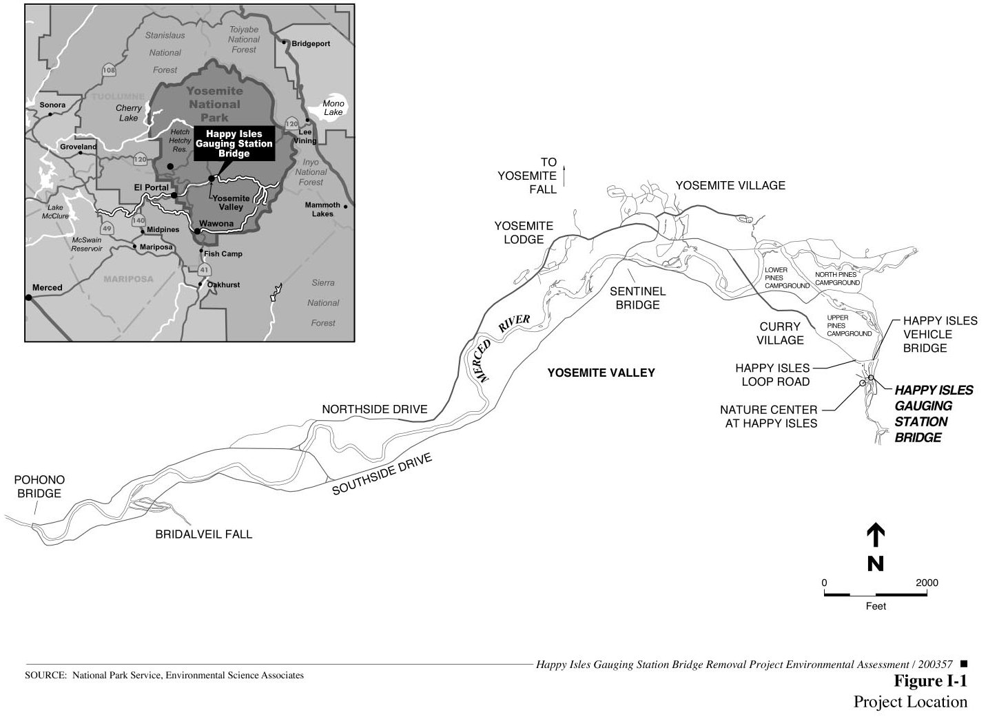
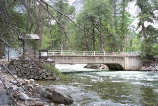 The
Happy Isles Gauging Station Bridge (Happy Isles footbridge) is located
on the main stem of the Merced River in Yosemite National Park, at the
east end of Yosemite Valley near the Nature Center at Happy Isles (
The
Happy Isles Gauging Station Bridge (Happy Isles footbridge) is located
on the main stem of the Merced River in Yosemite National Park, at the
east end of Yosemite Valley near the Nature Center at Happy Isles (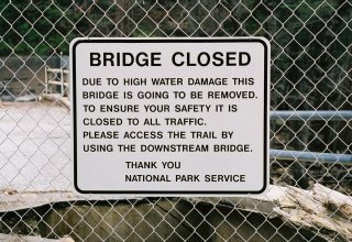 the
river-left side of the structure was imminent. Based on these findings,
the National Park Service closed the bridge in July 1997. Since that
time, the bridge has continued to deteriorate and is currently showing
impending signs of failure, with a large sinkhole appearing on the
river-left abutment. Subsequent evaluations by the Federal Highway
Administration in 1998 and 2001 indicated that the bridge was in
critical condition due to severe flood damage, and that the undermining
of the river-left abutment and subsequent settlement have rendered the
Happy Isles
the
river-left side of the structure was imminent. Based on these findings,
the National Park Service closed the bridge in July 1997. Since that
time, the bridge has continued to deteriorate and is currently showing
impending signs of failure, with a large sinkhole appearing on the
river-left abutment. Subsequent evaluations by the Federal Highway
Administration in 1998 and 2001 indicated that the bridge was in
critical condition due to severe flood damage, and that the undermining
of the river-left abutment and subsequent settlement have rendered the
Happy Isles 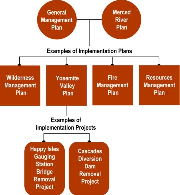